


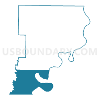
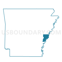
Mooney Voting District, Phillips County, Arkansas
About
Outline

Summary
| Unique Area Identifier | 527604 |
| Name | Mooney Voting District |
| County | Phillips County |
| State | Arkansas |
| Area (square miles) | 115.06 |
| Land Area (square miles) | 105.23 |
| Water Area (square miles) | 9.83 |
| % of Land Area | 91.46 |
| % of Water Area | 8.54 |
| Latitude of the Internal Point | 34.19154730 |
| Longtitude of the Internal Point | -90.96930820 |
Maps

Graphs
Select a template below for downloading or customizing gragh for Mooney Voting District, Phillips County, Arkansas


Neighbors
Neighoring Voting District (by Name) Neighboring Voting District on the Map
- Farrell Voting District, Coahoma County, MS
- Gunnison Voting District, Bolivar County, MS
- Mississippi Voting District, Desha County, AR
- Prairie Voting District, Arkansas County, AR
- Rena Lara Voting District, Coahoma County, MS
- Sherard Voting District, Coahoma County, MS
- Tappan 1 Voting District, Phillips County, AR
Top 10 Neighboring County Subdivision (by Population) Neighboring County Subdivision on the Map
- District 2, Coahoma County, MS (5,866)
- District 1, Bolivar County, MS (5,819)
- District 5, Coahoma County, MS (4,902)
- Tappan township, Phillips County, AR (1,500)
- Prairie township, Arkansas County, AR (609)
- Mooney township, Phillips County, AR (179)
- Mississippi township, Desha County, AR (74)
Top 10 Neighboring Unified School District (by Population) Neighboring Unified School District on the Map
- DeWitt School District, AR (8,785)
- Coahoma County School District, MS (8,189)
- North Bolivar School District, MS (3,264)
- Elaine School District, AR (1,227)
Top 10 Neighboring State Legislative District Lower Chamber (by Population) Neighboring State Legislative District Lower Chamber on the Map
- State House District 25, MS (29,000)
- State House District 12, AR (22,630)
- State House District 13, AR (21,757)
- State House District 29, MS (18,559)
Top 10 Neighboring State Legislative District Upper Chamber (by Population) Neighboring State Legislative District Upper Chamber on the Map
- State Senate District 5, AR (63,334)
- State Senate District 11, MS (48,319)
- State Senate District 12, MS (43,572)
Top 10 Neighboring 111th Congressional District (by Population) Neighboring 111th Congressional District on the Map
- Congressional District 1, AR (687,694)
- Congressional District 2, MS (668,263)
- Congressional District 4, AR (654,283)
Top 10 Neighboring Census Tract (by Population) Neighboring Census Tract on the Map
- Census Tract 9501, Bolivar County, MS (3,805)
- Census Tract 9502, Coahoma County, MS (2,672)
- Census Tract 4806, Phillips County, AR (1,837)
- Census Tract 9501, Desha County, AR (1,528)
- Census Tract 4801, Arkansas County, AR (1,435)
Top 10 Neighboring 5-Digit ZIP Code Tabulation Area (by Population) Neighboring 5-Digit ZIP Code Tabulation Area on the Map
- 72333, AR (667)
- 38720, MS (597)
- 38740, MS (466)
- 72048, AR (114)
- 72353, AR (114)
- 72367, AR (108)
- 72328, AR (64)
- 72379, AR (50)